Description
A visit to the depths of the woods. Today's hikers appreciate this conspiratory silence. As did the smugglers of olden days.
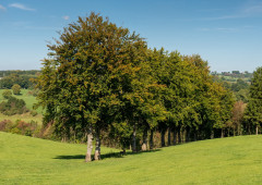
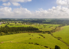
On the Hasselpath, the flat country around Büllingen turns into a series of remote valleys. Access to them seems to have something secret about it and is probably only familiar to those who can go through the woods without fear. Firs and beech trees line the path through the conservation area. We continue downhill until we hit the Belgian-German border. Here, the forest is so deep and dense that it swallows all sounds and becomes shrouded in mystery.
The Johnny Nysten Bridge is in memory of the soldier of the American occupying forces who helped German civilians out by smuggling commodities after the Second World War. When he was arrested, he was shot dead in cold blood. Before we stomp back up the hill, a clearing arouses our curiosity. Are we perhaps going to get to see the fauna of this majestic state forest today? Shortly before we reach our destination, we pass places at which young Americans and Germans fought. A war memorial was erected in their honour.
Hiking in the honeycomb network:
Follow these numbers: 31 > 38 > 43 > 32 > 33 > 31
More information: http://go.ostbelgien.eu/routenplaner-wandern
Advice
The Hasselpath memorial: Americans and Germans fought here during the 2nd World War. Of great educational value.
Details
-
Difficulty Medium
-
Physical condition
-
Experience
-
Landscape
-
Highest point
639 m
-
Lowest point
513 m
-
Best period for this activity
January
-
February
-
March
-
April
-
May
-
June
-
July
-
August
-
September
-
October
-
November
-
December
Safety instructions
A hike without particular difficulties. Dogs must be kept on a leash.
Recommended equipment
Wrap up water and a small snack. After the hike, stop for a break in Rocherath or Büllingen.
Information and additional links
East Belgium Tourist Agency npo
Hauptstraße 54
4780 Sankt Vith
+32 80 22 76 64
info@ostbelgien.eu
www.ostbelgien.eu
BE 0715 454 578 - RJP/RPM Eupen
Contact details
Departure
From the Hasselpath car park, take the forest road to Rocherath and the second road on the left. GPS coordinates: 50.3458870 - 6.311259
Arrival
Hasselpath parking lot.
Itinerary
Hiking in the honeycomb network:
Follow these numbers: 31 > 38 > 43 > 32 > 33 > 31
More information: http://go.ostbelgien.eu/routenplaner-wandern
By public transport
By train: www.belgianrail.be
By bus: www.infotec.be
From Brussels - Liège - Maastricht or Aachen (BAB 44) via motorway E 40, exit Eupen N 67 to Eupen N 68 direction Malmedy, at the Mont-Rigi junction direction Botrange
From Verviers or Trier (B51) via motorway E 42, exit Malmedy, N 68 to Malmedy, N 68 direction Eupen - Baraque Michel, at the junction Mont-Rigi direction Botrange
To park
Parking Hasselpath
Difficulty level
-
Difficulty Medium
-
Distance
7.5 km
- Duration
2.0 h.
- Positive altitude difference
126 m
- Positive altitude difference
126 m
Circular walks
Geological interest
Interest - The animal world
Dog Friendly
Difficulty level
- CountryBelgium
- RegionRégion Wallonne
- ProvinceVerviers
- DepartmentBüllingen