Description
Kleinweberbach, or the valley in which nature reveals itself in all its diversity.
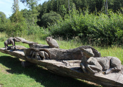
Uphill at first, to discover the unusual diversity of the flora and fauna here along the Kleinweberbach. On the right, some beavers have built their dam. Above the treetops a black stork flaps gracefully by. The further we press on into the valley, the stiller nature gets. Has it perhaps hidden in the bushes?
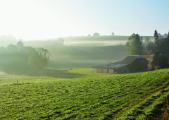
The twitter of birds and the gurgle of the stream can be heard from the undergrowth. The wayside flowers and the many butterflies which flutter around them, the hay meadows, mixed woodland and streams endow this place with a natural landscape that seems positively prodigal. When you reach the Knieberg, the route leads eastward into another valley, which is a conservation area. Here, the Großweberbach winds its way through a hay meadow in which a few cows graze peacefully. Following the stream, we reach the broad valley of the Our at sunset.
Hiking on the junction node network:
Follow these numbers: 1 > 6 > 29 > 26 > 62 > 51 > 6 > 1
More information: https://www.ostbelgien.eu/en/walking/hiking-route-planer
Advice
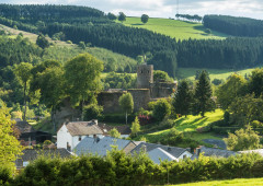
All around Schönberg, the hills provide magnificent panoramic views out on to the village on the Our and the heavily wooded landscape.
Details
-
Difficulty Medium
-
Physical condition
-
Experience
-
Landscape
-
Highest point
538 m
-
Lowest point
420 m
-
Best period for this activity
January
-
February
-
March
-
April
-
May
-
June
-
July
-
August
-
September
-
October
-
November
-
December
Safety instructions
Gentle valley ascent. The paths are wide, paved and rarely muddy. Dogs must be kept on a leash.
Recommended equipment
Hiking shoes with good ankle support. Catering available in Schönberg.
Information and additional links
East Belgium Tourist Agency npo
Hauptstraße 54
4780 Sankt Vith
+32 80 22 76 64
info@ostbelgien.eu
www.ostbelgien.eu
BE 0715 454 578 - RJP/RPM Eupen
Contact details
Departure
Cross the bridge of the big road to Sankt Vith, then follow the signs. GPS coordinates: 50.2893 - 6.2646
Arrival
At the village church.
Itinerary
Hiking on the junction node network:
Follow these numbers: 1 > 6 > 29 > 26 > 62 > 51 > 6 > 1
More information: https://www.ostbelgien.eu/en/walking/hiking-route-planer
Author's recommendations
The most beautiful hikes – Pleasure tours – www.ostbelgien.eu - Tourist Shop - Free brochures
Map recommended by the author
St.Vither Land & oberes Ameltal – Hiking map / IGN - 1:25.000 / www.ostbelgien.eu - Webshop
Difficulty level
-
Difficulty Medium
-
Distance
8 km
- Duration
2.5 h.
- Positive altitude difference
118 m
- Positive altitude difference
118 m
Circular walks
Viewpoint(s)
Catering points
Interest - The flora
Interest - The animal world
Dog Friendly
Difficulty level
- CountryBelgium
- RegionRégion Wallonne
- ProvinceVerviers
- DepartmentAmel