Description
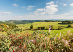
Characteristic of the country around Sankt Vith are the open landscapes and extensive agricultural areas. The only wooded area you cross is the Emmelserwald, not far from the border with the Walloon Region.
For the first 10 km, you ride on the Vennbahn towards Waimes. On the other side of the bushes, some lower-lying marsh areas, which are under conservation, lie along the former railway line. You go through them before you leave the Vennbahn towards Recht. Beyond the village, the large Emmelserwald awaits you. It’s uphill here. At an elevation of 580 m, on the southern edge of this area, you come across a café, also known as a beer museum on account of its unusual decoration, which consists of innumerable beer bottles from all over the world. It's part of the village of Rodt, through which you then pass shortly afterward on your way to Neundorf, a suburb of Sankt Vith. Neundorf's snow-white village church and the railway viaduct are major features of this place.
Advice: The slate mine at Recht. It's near Node 56. Until 1908, the famous blue slate was mined here. Guided tours through the mine, 800 m in length, are available from 10 am to 5 pm. (except mondays).
Follow the cycle route nodes: 84 > 50 > 35 > 39 > 32 > 34 > 48> 56 > 160 > 169 > 66 > 52 > 49 > 84
Advice
The slate mine at Recht. It's near Node 56. Until 1908, the famous blue slate was mined here. Guided tours through the mine, 800 m in length are available from 10 am to 5 pm. (except mondays).
Details
-
Difficulty Medium
-
Physical condition
-
Experience
-
Landscape
-
Highest point
569 m
-
Lowest point
437 m
-
Best period for this activity
January
-
February
-
March
-
April
-
May
-
June
-
July
-
August
-
September
-
October
-
November
-
December
Safety instructions
Beware of oncoming cyclists, walkers or other users on public roads and on the cycle path.
Recommended equipment
Normal cycling clothing including bike helmet. Depending on the weather, do not forget rainwear or windbreaker. Provide enough drinks and food for the journey.
Information and additional links
East Belgium Tourist Agency npo
Hauptstraße 54
4780 Sankt Vith
+32 80 22 76 64
info@ostbelgien.eu
www.ostbelgien.eu
BE 0715 454 578 - RJP/RPM Eupen
Contact details
Departure
Cultural Centre Triangel, Vennbahnstraße 2. With your back turned to the Café Trottinette take the cycle path on the right in the direction of Kn 50
Arrival
Cultural Centre Triangel, Vennbahnstraße 2.
Itinerary
Follow the cycle route nodes: 84 > 50 > 35 > 39 > 32 > 34 > 48> 56 > 160 > 169 > 66 > 52 > 49 > 84
Difficulty level
-
Difficulty Medium
-
Distance
27.7 km
- Duration
2.5 h.
- Positive altitude difference
268 m
- Positive altitude difference
268 m
Circular walks
Difficulty level
- CountryBelgium
- RegionRégion Wallonne
- ProvinceVerviers
- DepartmentAmel