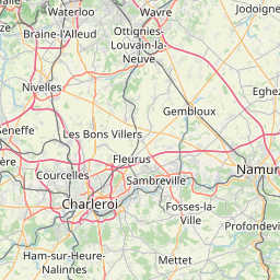


Elsenborn
Mysterious vastness of a historical cultural landscape


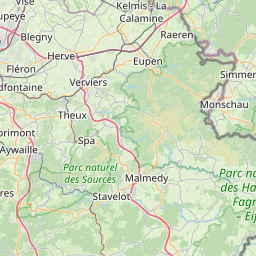
Elsenborn
At 635 metres, Elsenborn is one of Belgium’s highest villages. With some 1,000 inhabitants, it is especially characterised by the military training ground and its heath landscape, which is veined with open stream valleys and can boast a considerable diversity of species. This is a landscape which was typical of many of the villages in the Hocheifel in earlier times. In Elsenborn, this unique form of scenery was able to be preserved by the establishment of the military training ground, which is 28 km² in area. Today, this open belt of land is an important habitat for numerous animals and plants.
Point of interest

Elsenborn viewpoint indicator
The panorama board at Elsenborn is not far from hiking node 67 and the Vennhof cross. The site is surrounded by lush green meadows and offers a good view of the foothills of the Hohes Venn. The orientation board focuses on the military training area, the flora and fauna of the High Fens, measures to preserve the cultural landscape, special landscapes such as the Hohe Mark, the Schwalmbach Valley, the Bieley Rock and places of interest in the surrounding area.

Former boundary stones
It was on today's military training ground at Elsenborn that the border between the duchies of Jülich and Luxembourg ran in former centuries. At that time, the difficult terrain was used by the inhabitants of the villages of Elsenborn (Duchy of Luxembourg) and Kalterherberg (Duchy of Jülich) as pasture for the livestock – above all the sheep – but also for the procurement of hay and straw. Because of the imprecise boundary marking, however, the shepherds and farmers of the two villages repeatedly got involved in disputes about the actual course of the boundary, and that, indeed, led to the ‘abduction’ of the Elsenborn sheep flock to Kalterherberg in 1664. This ‘border war’ went on for a long time, for it was not until 1791 that the tough terrain was remeasured and the boundary painstakingly marked out with stones. However, the boundary became obsolete again just four years later, because the French had conquered the area and dissolved the old duchies. Even today, a row of stones marks the former boundary, and in fact the boundary ditch is still preserved in some places. A few boundary stones, some of which were damaged, have been removed and re-erected near the Truschbaum (Lagerstrasse, not far from the water tower) for their own protection. This beech, which lived to be approximately 200 years old and presumably stood out for a long time as the only tree in the landscape, served the people as a striking landmark in the Fens. In January 1984, however, the old, sick tree fell victim to a winter storm and was replaced by a new beech in the autumn of the same year.

Winter sports
In the winter, Elsenborn is largely devoted to winter sports. The cross-country ski trails are prepared for both the classical and the skating style and enable visitors to do laps of up to 14 kilometres. Altogether there are 800 pairs of cross-country skis waiting to be hired out to individuals, groups, school classes and families. The newly built biathlon centre at Herzebösch attracts professionals and young talents and is also available to those who are interested in leisure sports. However, the planned touristic use goes further than that: there is shooting for everyone, i. e. all those who wish to try out the biathlon experience. The amenities include laser shooting, and shooting with air guns and biathlon rifles. In the summer the facility remains open for rollerskiers and in-line skaters, who can enjoy the charming landscape on the freshly sealed piste.

Military training ground
The Elsenborn military training ground was established for the Prussian Army in 1894. At that time, Elsenborn was part of the Prussian Rhine province and thus also part of the German Empire. The first soldiers were garrisoned in tents and with village farmers until, as from 1895, the ‘Elsenborn camp' developed with various buildings: living quarters and dormitories, stables, a post office, feed barns for the animals, a bath house etc. At times, there were up to 5000 soldiers and 1500 horses accommodated here. From 1895 to 1939 the camp was connected to Sourbrodt station by a narrow-gauge railway. It was mainly used for the transportation of oats, barley and straw for the horses, and the conveyance of the soldiers who went to the shops and taverns in nearby Sourbrodt. Today's connecting road between Elsenborn and Kalterherberg (D) was built as a by-pass between 1913 and 1915. During the First World War, Russian prisoners were among those deployed as labourers in the building of the road. The original direct route through the training ground is still clearly visible today. The military training ground lies to the north of the village of Elsenborn. It has an area of 28 km² and is one of the Belgian armed forces’ largest training grounds. That military use has caused the spreading of fertilisers and the reforestation of the heath with spruces to be prohibited. These circumstances and the controlled fires which are allowed to burn on a regular basis have ensured that the spignel meadows and heathland, typical 200 years ago of all the villages in the Hocheifel, have been conserved. Numerous species of plant and animal have found a refuge here.

Flora and fauna
On account of its rare fauna and flora, the majority of the military training ground is considered to be an area worthy of protection, and for that reason it has been included in the Natura 2000 programme. In this Europe-wide network, coherent protected zones are designated which help to ensure the continued existence of wild indigenous plants and animals and their habitat. The soil on the military training ground, low in nutrients though it is, enables rare plants to spread well: in the spring, daffodils blossom here. Shortly after that the meadows are full of brilliant white spignel, and in summer the arnica flowers in great numbers too. Purple heather and cowberries colour the landscape in the autumn. More than 78 bird species are native to the training ground, and it is above all the whinchat and various types of larks and pipit, all of which nest on the ground, that find ideal living conditions here, as does the black stork. Notable among the fauna are also more than 30 species of butterfly and moth, including the violet copper and a very rare type of fritillary, which have settled here as typical inhabitants of a cold, damp habitat.

Measures to conserve the cultural landscape
Particularly on account of its military use and the fires which are allowed to burn on a regular basis, the hay meadows with spignel, and the heathland, of the kind that surrounded almost every village in the Hocheifel 200 years ago, have been able to subsist on the training ground at Elsenborn. These cultural landscapes came about in the Middle Ages as a result of deforestation of beech and oak woods and the subsequent shifting cultivation. Shifting cultivation is a form of slash-and-burn in which the turf layer is peeled off and burned and the ash used as a fertiliser. Grazing sheep prevented trees and shrubs from growing and kept these surfaces free. Various measures have been taken to preserve this unique cultural landscape on the military training ground and restore it. The principal and most effective method is the controlled burning off of certain areas. Every year in spring, before the breeding season, large areas are burned off on the Elsenborn military training ground by the military and forestry administration. This helps the heath to stay young, impedes the spread of pioneer plants such as broom and birch, and enables the growth of plant species whose seeds need to fall on bare soil in order to be able to germinate. On degraded areas of the heath which have a humus cover of several centimetres, the technique of sod lifting is used. The turf, rich in humus, is removed with an excavator, so that the seeds of the heathland plants present in the soil can germinate, even after 50 years. All these measures are carried out instead of the former extensive farming, and they now contribute to the conservation of the open heathland.

Hohe Mark – a remarkable landscape
Aan de rand van het militaire oefenterrein, waar het vuur niet komt bij het gecontroleerd afbranden om het heidelandschap te behouden, zijn enkele overblijfselen van oude bossen met eiken- en rode beukenbomen bewaard gebleven. De Hohe Mark bijvoorbeeld is een beukenbos met opvallende boomvormen gekenmerkt door volgroeide stompscheuten. Door het bos te beheren als hakhoutbos, waarbij bomen regelmatig op stok worden gezet, ontstaan deze zeer typische boomvormen. Het gebied is geklasseerd als beschermd landschapsgebied.

Schwalmbach valley and Bieley rock
The Schwalmbach valley is a conservation area, 209 hectares in size, in the border region between Belgium and Germany. The source of the Schwalm is not far from the N658 between Rocherath and Wahlerscheid (D). The stream runs through the military zone and is fed by several small tributaries. After only a short section of about 5 kilometres, it crosses the border to Germany, being named the Perlenbach from then on because of the pearl oyster which lives in it. The meadows in the valley, low in nutrients, were used for haymaking for centuries, until the farmers abandoned these remote fields as uneconomical. In the ensuing period, the meadows were planted with fast-growing spruces and lost their original character. It was not until the culture and nature conservationalists of the German-Belgian Naturpark Hohes Venn-Eifel became active that policy changed and the old stream meadows, which are covered in spring with a carpet of yellow daffodils, were reclaimed. Having said that, throughout the year the Schwalmbach valley presents nature lovers and hikers with some magnificent scenery. One special attraction is the Bieley, an impressive rock high up above the valley. From there, a breathtaking view opens up out over the valley in which the wild Schwalmbach meanders. Because the rock is located in a security zone of the Elsenborn military training ground, access to the Bieley is regularly barred on account of firing practice. So, before visitors set foot in the area, they should make sure to find out whether or not any firing practice sessions are due to take place. The Bieley can be accessed most easily, though not exclusively, from the German side. Information on closures: https://butgenbach.be/schiessuebungen-lager-elsenborn/

Herba Sana – the health garden
Healing with herbs, ‘Health in Harmony with Nature’ is the motto of the natural remedy manufacturer Ortis. In Herba Sana, the company’s own physic garden, the philosophy of this family enterprise is illustrated. There are 120 different medicinal herbs flourishing in these grounds, which have an area of two hectares. 450 information panels guide visitors through the Herba Sana garden and explain the multifarious applications to which these plants can be put. One of the beds is dedicated to digestive health, whilst another contains 25 healing plants which make it possible to put together a little apothecary from Mother Nature. Out beyond these diligently arranged beds, the natural landscape of the High Fens extends. In it, there are another 80 wild plants waiting to be discovered. Guided tours for groups or programme proposals with ORTIS are available on request. info@herba-sana.be www.herba-sana.be

‘Truschbaum’
The Truschbaum is up near Griesdeck on Elsenborn’s Lagerstrasse. Where today’s tree stands there used to be an ancient beech which, according to the tradition, lived to be approximately 200 years old. For a very long time, that tree presumably stood out as the only one in the landscape and served as a striking landmark for hikers and smugglers in the Fens. Its appearance put one in mind of a bunch of flowers. The vernacular suggests that that was why it was given the name ‘Trusch’, for in the Elsenborn dialect, ‘Trusch’ means about the same as ‘bunch’. Scientists, by contrast, say that ‘Trusch’ denotes the stony ground in which the tree stands. ‘Trusch’ is the name of a large Elsenborn cadastre which extends all the way up to the Truschbaum. The fact is that in old German, ‘d’Rusch’ means rough, stony ground. As long ago as 1830, the Truschbaum was described as ‘completely hollowed out inside’. Numerous attempts to save it were brought to an abrupt end by a severe winter storm in January 1984. However, so that this landmark of Elsenborn could continue to exist in spite of that, a new European beech was planted in the same place in November 1984. Nine of the boundary stones (1791) from the former Jülich-Luxembourg border, which had originally stood on what is now the military training ground, were re-erected around the Truschbaum for their own protection.

The legend of the Lützevennsmännchen
Naturally, there used to be hunting in the woods and Venn valleys around what is now the military training ground. On one such hunt, three hunters were pursuing a hare, but it managed to get away from them again and again. Whilst two of them soon abandoned the chase, the third continued doggedly and disappeared in the swampy thickets, never to be seen again. According to the legend, however, he continued to roam the Fens as a ghost and appeared in and around the Lützevenn from time to time. Some of the encounters with the ghost were said to be peaceful, whilst others were described as terrifying. It was said that the Lützevennsmännchen, as the apparition was called, once joined some woodcutters at their fire, warmed itself up a bit, said a few words and vanished again. Others however, in particular those who made fun of the revenant, were said to have had a hard time at the hands of the Lützevennsmännchen: it grabbed them by the neck and lifted them up into the air. Some were said to have gone grey after such an encounter. Earlier, the people in our villages used to tell lots of stories about the little ghost. And they firmly believed that the Lützevennsmännchen really existed.
Contact us
High Fens House for Tourism – East Belgium NPO
East Belgium
Place Albert I 29a
4960 Malmedy
T. +32 80 33 02 50
E. info@ostbelgien.eu
S. www.ostbelgien.eu