Go to content

Kids on Tour - Where knights once walked

}
Hiking Trail recommended route

Kids on Tour - Where knights once walked

Hiking Trail
Logo East Belgium Tourist Agency
Responsible for this content
East Belgium Tourist Agency Verified partner  Explorers Choice 
  • Kids on Tour - Burg-Reuland
    Kids on Tour - Burg-Reuland
    Photo: Benno Hermes, CC BY-SA, East Belgium Tourist Agency
To a ruined castle, one thousand years old
moderate
Distance 2.5 km
0:45 h
71 m
71 m
422 m
351 m

Today, you can walk in the footsteps of the knights of old. This short circular route begins with a climb to the church of Weweler. From the graveyard, there is a magnificent view down the valley of the River Our. At the church itself, you can relax after the climb at the two tables made from huge tree trunks. Look at all those tree-rings! Each one represents a year of life. You can count the rings to find out how old the trees were before they were made into tables.

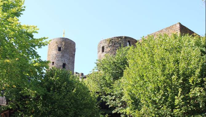
Follow the Way of the Cross downhill in the direction of Burg-Reuland. The remains of this 12th-century castle – visible from afar – rise impressively on a slight rise above the village. These are among the largest and most beautiful castle ruins in the Ardennes region. Once at the bottom, one route takes you round the village and another up to the ruins. To return to the starting point, you can walk along a section of the Vennbahn, a disused railway line.

Author’s recommendation

More information under: www.ostbelgien.eu/en/walking/walking-with-kids  

The brochure is only available in German, French and Dutch.

Profile picture of Tourismusagentur Ostbelgien
Author
Tourismusagentur Ostbelgien
Update: August 03, 2023
Difficulty
moderate
Technique
Stamina
Experience
Landscape
Highest point
422 m
Lowest point
351 m
Best time of year
Jan
Feb
Mar
Apr
May
Jun
Jul
Aug
Sep
Oct
Nov
Dec

Track types

Asphalt 87.90%Forested/wild trail 0.84%Path 9.71%Road 1.54%
Asphalt
2.2 km
Forested/wild trail
0 km
Path
0.2 km
Road
0 km
Show elevation profile

Safety information

Somewhat suited for prams

Tips and hints

East Belgium Tourist Agency

Hauptstraße 54

4780 St. Vith

Tel. +32 80 22 76 64

info@ostbelgien.eu 

www.ostbelgien.eu  

Start

Ulfstraße, Weweler (Burg Reuland) | Parking at the Vennbahn cycling route GPS: 50.196681, 6.149456
Coordinates:
DD
50.196138, 6.149566
DMS
50°11'46.1"N 6°08'58.4"E
UTM
32U 296564 5564327
w3w 
///undergoing.panels.balancer

Destination

Ulfstraße, Weweler (Burg Reuland) | Parking at the Vennbahn cycling route GPS: 50.196681, 6.149456

Public transport

By train: www.belgiantrain.be 

By bus:  www.letec.be 

Parking

Ulfstraße, Weweler (Burg Reuland) | Parking at the Vennbahn cycling path

Coordinates

DD
50.196138, 6.149566
DMS
50°11'46.1"N 6°08'58.4"E
UTM
32U 296564 5564327
w3w 
///undergoing.panels.balancer
Get there by train, car, bike, or on foot!

Equipment

Make sure to wear hiking shoes and clothes according to the weather. 

Similar routes nearby

  • Pleasure tour 9 – Welcome up here
  • Pleasure tour 2 – Down there flows a river
  • Planetenweg
  • Naturlehrpfad Rodt
  • Pleasure tour 25 – An endless forest
 These suggestions were generated by our system
Difficulty
moderate
Distance
2.5 km
Duration
0:45 h
Ascent
71 m
Descent
71 m
Highest point
422 m
Lowest point
351 m
Round trip Scenic Family-friendly Cultural/historical interest Cableway ascent/descent Suitable for strollers

Statistics

  • Content
  • Show images Hide images
Features
Maps and trails
  • 2 Waypoints
  • 2 Waypoints
Distance  km
Duration : h
Ascent  m
Descent  m
Highest point  m
Lowest point  m
Push the arrows to change the view