Go to content

Kids on Tour - Bathed in green

}
Hiking Trail recommended route

Kids on Tour - Bathed in green

Hiking Trail
Logo East Belgium Tourist Agency
Responsible for this content
East Belgium Tourist Agency Verified partner  Explorers Choice 
  • Kids on Tour - Eupen
    Kids on Tour - Eupen
    Photo: Benno Hermes, CC BY-SA, East Belgium Tourist Agency

A stream and a walk in the forest

moderate
Distance 6.1 km
1:40 h
89 m
89 m
396 m
318 m

Rich in its variety, this walk takes you through the Hertogenwald (the Dukes’ Wood) near Eupen. A narrow path follows a stream called the Hill (Helle in French), which has its source near Botrange, the highest point in Belgium, and flows into the River Weser in the Unterstadt district of Eupen. Tree roots and rocks on the bank of the stream provide a natural obstacle course, where you can play the lava game (see tip) or observe life in the water and count the animals that live here. The ground in this area consists of a very special form of soil: peat. This is what turns the water in the stream brown.

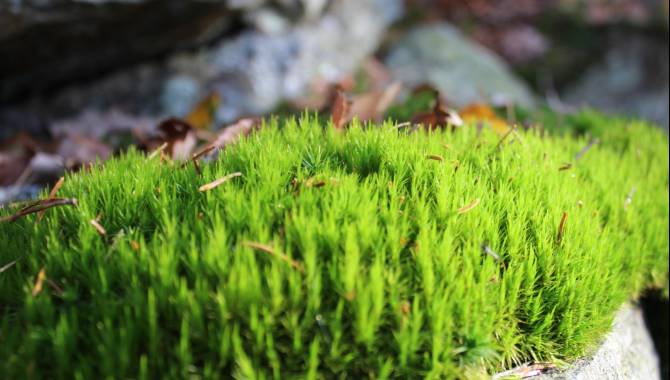
Leave the stream to dive deep into the forest – a mixture of broadleaf and coniferous woodland. Keep your eyes peeled for oddly shaped sticks: there are masses of them here, each forming weirdly sculptural shapes. No two are alike. You will also find lots of blueberry bushes, which come into fruit in July. Soon you reach a place called Binsterkanzel, where numerous rocks are covered in moss. In some places the moss is so long that it looks like extravagant hairstyles: who can spot the funniest? Finally, an avenue bordered by meadows takes you back to the starting point.

Author’s recommendation

More information under: www.ostbelgien.eu/en/walking/walking-with-kids 

The brochure is only available in German, French and Dutch.

Profile picture of Tourismusagentur Ostbelgien
Author
Tourismusagentur Ostbelgien
Update: August 03, 2023
Difficulty
moderate
Stamina
Experience
Landscape
Highest point
396 m
Lowest point
318 m
Best time of year
Jan
Feb
Mar
Apr
May
Jun
Jul
Aug
Sep
Oct
Nov
Dec

Track types

Asphalt 0.06%Forested/wild trail 68.91%Path 31%
Asphalt
0 km
Forested/wild trail
4.2 km
Path
1.9 km
Show elevation profile

Safety information

Not suited for prams

Tips and hints

East Belgium Tourist Agency

Hauptstraße 54

4780 St.Vith

Tel. +32 80 22 76 64

info@ostbelgien.eu 

www.ostbelgien.eu   

Start

Eupen, Parking at the street "Binsterweg" GPS: 50.6125184,6.0533892
Coordinates:
DD
50.613242, 6.053111
DMS
50°36'47.7"N 6°03'11.2"E
UTM
32U 291521 5610962
w3w 
///chalked.conifers.chained

Destination

Eupen, Parking at the street "Binsterweg" GPS: 50.6125184,6.0533892

Public transport

By train: www.belgiantrain.be   

By bus: www.letec.be  

Parking

Parking at the street "Binsterweg"

Coordinates

DD
50.613242, 6.053111
DMS
50°36'47.7"N 6°03'11.2"E
UTM
32U 291521 5610962
w3w 
///chalked.conifers.chained
Get there by train, car, bike, or on foot!

Equipment

Make sure to wear hiking shoes and clothes according to the weather. 

Similar routes nearby

  • Pleasure tour 24 – Hertogenwald
  • Gnomes path
  • FOXY - Walderlebnispfad an der Eupener Wesertalsperre
  • Pleasure tour 23 – So close and yet so far
  • Pleasure tour 26 – The forest of the Dukes
 These suggestions were generated by our system
Difficulty
moderate
Distance
6.1 km
Duration
1:40 h
Ascent
89 m
Descent
89 m
Highest point
396 m
Lowest point
318 m
Round trip Scenic Family-friendly Flora

Statistics

  • Content
  • Show images Hide images
Features
Maps and trails
Distance  km
Duration : h
Ascent  m
Descent  m
Highest point  m
Lowest point  m
Push the arrows to change the view