Go to content

Kids on Tour - Beckoned by the sound of a waterfall

}
Hiking Trail recommended route

Kids on Tour - Beckoned by the sound of a waterfall

Hiking Trail · Malmedy
Logo East Belgium Tourist Agency
Responsible for this content
East Belgium Tourist Agency Verified partner  Explorers Choice 
  • Kids on Tour - Longfaye
    Kids on Tour - Longfaye
    Photo: Benno Hermes, CC BY-SA, East Belgium Tourist Agency

Through a fantasy realm to the black rocks

moderate
Distance 3 km
0:50 h
64 m
64 m
571 m
513 m

First, you walk between meadows on the outskirts of the village of Longfaye. It is quiet, with barely any cars to disturb the peace. Even more so as you turn into the old sunken road. A mysterious atmosphere will immediately envelop you, as if you had entered another realm – the realm of fantasy. As you walk past strangely shaped trees, you can make out faces, human shapes and animals in their trunks and branches. Soon, the path enters a tree-lined avenue that offers soothing shade on warm summer days. The forests around here are typical of the Ardennes region.


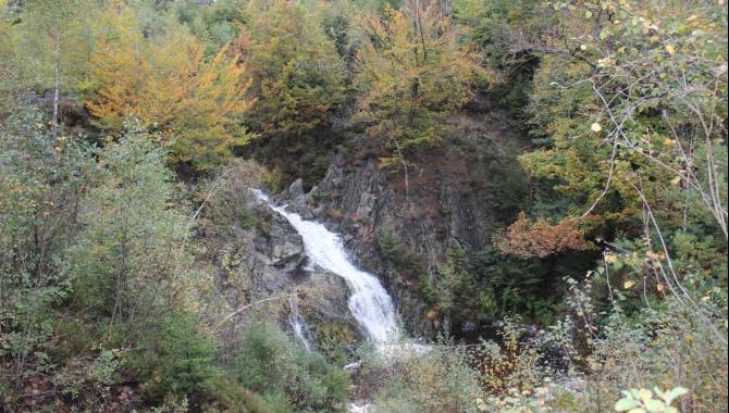
A narrow path leads down the Bayehon waterfall. The noise it makes can be heard from afar, pulling you towards it. Just before you get there, the path becomes criss-crossed by tree roots. At last, you reach the cool water. If the river that feeds it contains enough water, it falls spectacularly over the black rocks. Climb down to the shore and dip your toes into the chilly water. Build towers out of rocks and pebbles, or try using the rocks as stepping stones.

Author’s recommendation

More information under: www.ostbelgien.eu/en/walking/walking-with-kids 

The brochure is only available in German, French and Dutch.

Profile picture of Tourismusagenturagentur Ostbelgien
Author
Tourismusagenturagentur Ostbelgien
Update: August 03, 2023
Difficulty
moderate
Technique
Stamina
Experience
Landscape
Highest point
571 m
Lowest point
513 m
Best time of year
Jan
Feb
Mar
Apr
May
Jun
Jul
Aug
Sep
Oct
Nov
Dec

Track types

Forested/wild trail 71.71%Path 14.37%Unknown 13.91%
Forested/wild trail
2.1 km
Path
0.4 km
Unknown
0.4 km
Show elevation profile

Safety information

Not suited for prams

Tips and hints

East Belgium Tourist Agency

Hauptstraße 54

4780 St. Vith

Tel. +32 80 22 76 64

info@ostbelgien.eu 

www.ostbelgien.eu 

Start

Longfaye, Chemin de la Cascade | Parking at the end of the street GPS: 50.475395, 6.085307
Coordinates:
DD
50.476654, 6.085636
DMS
50°28'36.0"N 6°05'08.3"E
UTM
32U 293225 5595687
w3w 
///reversals.wised.figments

Destination

Longfaye, Chemin de la Cascade | Parking at the end of the street GPS: 50.475395, 6.085307

Public transport

By train: www.belgiantrain.be  

By bus:  www.letec.be  

Parking

Longfaye, Chemin de la Cascade | Parking at the end of the street 

Coordinates

DD
50.476654, 6.085636
DMS
50°28'36.0"N 6°05'08.3"E
UTM
32U 293225 5595687
w3w 
///reversals.wised.figments
Get there by train, car, bike, or on foot!

Equipment

Make sure to wear hiking shoes and clothes according to the weather. 

Similar routes nearby

  • Pleasure tour 3 – The Bayehon waterfall
  • Vennwanderung am Naturparkzentrum Botrange
  • Educational trail 'The Colours of the Fens'
  • At the top of Belgium
  • The small fens of Xhoffraix
 These suggestions were generated by our system
Difficulty
moderate
Distance
3 km
Duration
0:50 h
Ascent
64 m
Descent
64 m
Highest point
571 m
Lowest point
513 m
Round trip Scenic Family-friendly Geological highlights Cableway ascent/descent

Statistics

  • Content
  • Show images Hide images
Features
Maps and trails
  • 1 Waypoints
  • 1 Waypoints
Distance  km
Duration : h
Ascent  m
Descent  m
Highest point  m
Lowest point  m
Push the arrows to change the view