Go to content

Kids on Tour - A love story with violets

}
Hiking Trail recommended route

Kids on Tour - A love story with violets

Hiking Trail · Kelmis
Logo East Belgium Tourist Agency
Responsible for this content
East Belgium Tourist Agency Verified partner  Explorers Choice 
  • Eyneburg
    Eyneburg
    Photo: ostbelgien.eu, CC BY-SA, East Belgium Tourist Agency

In an old mining district, an even older castle

easy
Distance 5 km
1:20 h
55 m
55 m
227 m
180 m

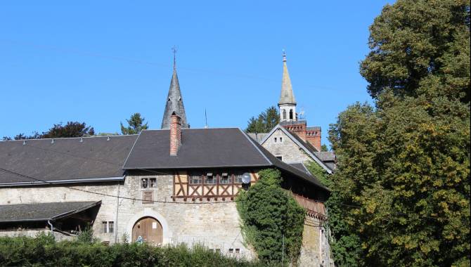
The walk in Kelmis (called La Calamine in French) takes you through this former mining district to Eyneburg Castle. Metal ores – and especially zinc ore – were extracted from underground mining galleries (tunnels) around here. A number of unusual and rare plants thrive in the metal-rich soil, including daffodils and orchids – and Calamine Violets, which are found almost nowhere else. Eyneburg Castle is another highlight of this walk. According to legend, Emma, the daughter of Emperor Charlemagne, lived in the castle some fourteen hundred years ago. That is why the castle is also called Emmaburg. The story goes that she fell in love with a friend of her father, called Einhard, but they didn’t dare tell her father, and so met in secret in this castle.

The walk begins at the Casino pond, where the zinc ores were washed. From here you follow the course of the River Göhl, past rugged rocks and an old castle wall. The Eyneburg Castle stands on a hilltop. The Hohnbach valley begins right behind it – awash with wild daffodils in spring. You soon come to an old railway line, which you follow for a while through the valley. This railway used to carry ore to Kelmis. At the end, you go through a turnstile, and then follow a small path back to the River Göhl.

Author’s recommendation

More information under: www.ostbelgien.eu/en/walking/walking-with-kids

The brochure is only available in German, French and Dutch.

Profile picture of Tourismusagentur Ostbelgien
Author
Tourismusagentur Ostbelgien
Update: September 06, 2023
Difficulty
easy
Technique
Stamina
Experience
Landscape
Highest point
227 m
Lowest point
180 m
Best time of year
Jan
Feb
Mar
Apr
May
Jun
Jul
Aug
Sep
Oct
Nov
Dec

Track types

Forested/wild trail 84.53%Path 15.11%Road 0.34%
Forested/wild trail
4.3 km
Path
0.8 km
Road
0 km
Show elevation profile

Safety information

Not suited for prams

Tips and hints

East Belgium Tourist Agency

Hauptstraße 54

4780 St.Vith

Tel. +32 80 22 76 64

info@ostbelgien.eu

www.ostbelgien.eu  

Start

N3 Aachen > Liège | Parking: Lütticher Straße - Casinostraße (Kelmis)
Coordinates:
DD
50.712720, 6.011076
DMS
50°42'45.8"N 6°00'39.9"E
UTM
32U 288994 5622140
w3w 
///mascot.modules.seasons

Destination

N3 Aachen > Liège | Parking: Lütticher Straße - Casinostraße (Kelmis)

Public transport

By train: www.belgiantrain.be  

By bus: www.letec.be 

Parking

Parking: Lütticher Straße - Casinostraße (Kelmis/La Calamine), GPS: 50.712690, 6.011125

Coordinates

DD
50.712720, 6.011076
DMS
50°42'45.8"N 6°00'39.9"E
UTM
32U 288994 5622140
w3w 
///mascot.modules.seasons
Get there by train, car, bike, or on foot!

Equipment

Make sure to wear hiking shoes and clothes according to the weather. 

Similar routes nearby

  • Pleasure tour 14 – In the land of the calamine
  • Industrial Heritage Trail Kelmis
  • Göhl valley route Via Gulia - Kelmis - Gulpen
  • Pleasure tour 22 – A walk for the soul
  • Sculpture trail: "In the Footsteps of the Stones"
 These suggestions were generated by our system
Difficulty
easy
Distance
5 km
Duration
1:20 h
Ascent
55 m
Descent
55 m
Highest point
227 m
Lowest point
180 m
Round trip Family-friendly Cultural/historical interest Geological highlights

Statistics

  • Content
  • Show images Hide images
Features
Maps and trails
  • 2 Waypoints
  • 2 Waypoints
Distance  km
Duration : h
Ascent  m
Descent  m
Highest point  m
Lowest point  m
Push the arrows to change the view