Go to content

Kids on Tour - A real mountain hike

}
Hiking Trail recommended route

Kids on Tour - A real mountain hike

Hiking Trail · Malmedy
Logo East Belgium Tourist Agency
Responsible for this content
East Belgium Tourist Agency Verified partner  Explorers Choice 
  • Kids on Tour - Malmedy
    Kids on Tour - Malmedy
    Photo: Benno Hermes, CC BY-SA, East Belgium Tourist Agency

Up hill and down dale, then “Hello, wild boar!”

difficult
Distance 5.1 km
2:00 h
105 m
105 m
528 m
433 m

This walk in the spectacularly beautiful Trôs-Marêts valley is an absolute highlight for children (and not just for them!). Because what do little explorers really want? Adventures! Here they can try a bit of rock-climbing – and test the limits of their daring. They can jump over giant tree-roots and splash about in water. This circular tour is also a wonderful way to bring our young explorers into close contact with river- and forest-life. And an animal surprise awaits them at the very end of the trail: a herd of wild boars lives in a fenced-off area a short distance from the path. In spring, the sows (female wild boars) can be seen tending to their families of little piglets.

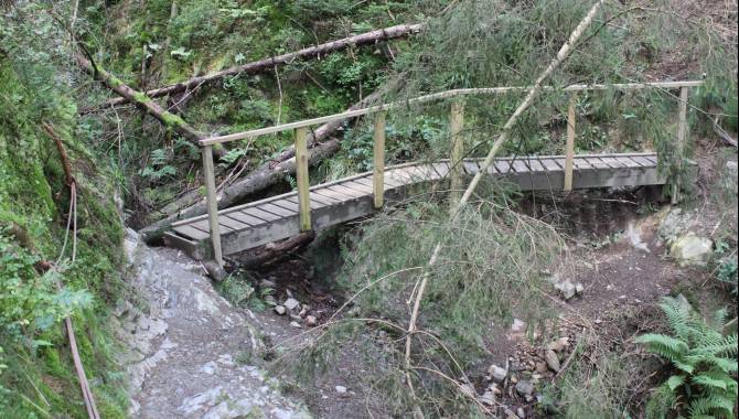
The first part of the route takes you through coniferous forest. As you descend into the valley, the sound of the rushing torrent becomes ever louder. The path starts out stony, but increasingly becomes laced with tree roots. Rocks rise up to make their mark on the landscape. Down in the valley, a bridge spans the fast-flowing river, which branches off into several small waterfalls. On the other side of the bridge, you have to do a bit of climbing. The steel cables anchored to the rock offer you support on the sometimes slippery stones. Where the path follows the river, it rises more gently uphill. The final section leads you back through the forest, under tall trees and past lush green meadows.

Author’s recommendation

More information under: www.ostbelgien.eu/en/walking/walking-with-kids 

The brochure is only available in German, French and Dutch.

Profile picture of Tourismusagentur Ostbelgien
Author
Tourismusagentur Ostbelgien
Update: August 03, 2023
Difficulty
difficult
Technique
Stamina
Experience
Landscape
Highest point
528 m
Lowest point
433 m
Best time of year
Jan
Feb
Mar
Apr
May
Jun
Jul
Aug
Sep
Oct
Nov
Dec

Track types

Dirt road 19%Forested/wild trail 67.25%Path 13.74%
Dirt road
1 km
Forested/wild trail
3.4 km
Path
0.7 km
Show elevation profile

Safety information

Not suitable for prams. Difficult to walk on in winter and when wet.

Tips and hints

East Belgium Tourist Agency

Hauptstraße 54

4780 St. Vith

Tel. +32 80 22 76 64

info@ostbelgien.eu 

www.ostbelgien.eu   

Start

Route de la Ferme Libert 33, 4960 Malmedy GPS: 50.446372, 6.033063
Coordinates:
DD
50.446460, 6.033717
DMS
50°26'47.3"N 6°02'01.4"E
UTM
32U 289407 5592477
w3w 
///netball.hobbies.certainly

Destination

Route de la Ferme Libert 33, 4960 Malmedy GPS: 50.446372, 6.033063

Public transport

 Mit dem Zug: www.belgianrail.be 

Mit dem Bus:  www.infotec.be 

Directions

Bitte benutzen Sie den Anfahrtsplaner.

Parking

Route de la Ferme Libert. Achtung die Parkings des Restaurants und Hotels sind ausschließlich Kunden vorbehalten.

Coordinates

DD
50.446460, 6.033717
DMS
50°26'47.3"N 6°02'01.4"E
UTM
32U 289407 5592477
w3w 
///netball.hobbies.certainly
Get there by train, car, bike, or on foot!

Book recommendation by the author

Kids on tour – Wander- und Radausflüge mit Kindern - www.ostbelgien.eu - Tourist Shop - Gratis Veröffentlichungen

Equipment

Make sure to wear hiking shoes and clothes according to the weather. 

Similar routes nearby

  • Pleasure tour 4 – The canyon of the Trôs-Marets
  • Puddingstone Nature Trail Malmedy
  • Pleasure tour 13 – The land of Négus
  • Pleasure tour 16 – The ridges above the Warche valley
  • The small fens of Xhoffraix
 These suggestions were generated by our system
Difficulty
difficult
Distance
5.1 km
Duration
2:00 h
Ascent
105 m
Descent
105 m
Highest point
528 m
Lowest point
433 m
Round trip Family-friendly Geological highlights Cableway ascent/descent

Statistics

  • Content
  • Show images Hide images
Features
Maps and trails
Distance  km
Duration : h
Ascent  m
Descent  m
Highest point  m
Lowest point  m
Push the arrows to change the view